Drone in agriculture: applications and their future
- marco Fiorentini
- Jun 25, 2024
- 8 min read

Introduction to Agricultural Drones
Why should farmers and cooperative be interested in drones? in this article we are going to explain why more and more we are hearing and talking about drones, but if we have to sum it up in a few concepts here is a list of 8 applications:
Nutritional monitoring
Water status monitoring
Generation of prescription maps for fertilization, irrigation, and plant protection products
Distribution of auxiliary insects (used in organic farming but also in integrated and conventional farming)
Distribution of fertilizer and plant protection products
Agricultural insurance
Agricultural Certification and supply chain control
Let's start with the basics, drones are nothing more than means of transportation, and they alone have no potential application in agriculture. But if they are equipped with special cameras or fluid or solid distributors, then they become our allies. Also to be able to use a drone in agriculture need to have a license, insurance and registration, just like a car.
Types of Drones Used in Agriculture
The use of drones in agriculture can be classified differently according to their application or type.
Classification based on the application
Based on the type of application we have two main categories of application fo drones in agriculture, which are Survey and Distribution of agronomic inputs.
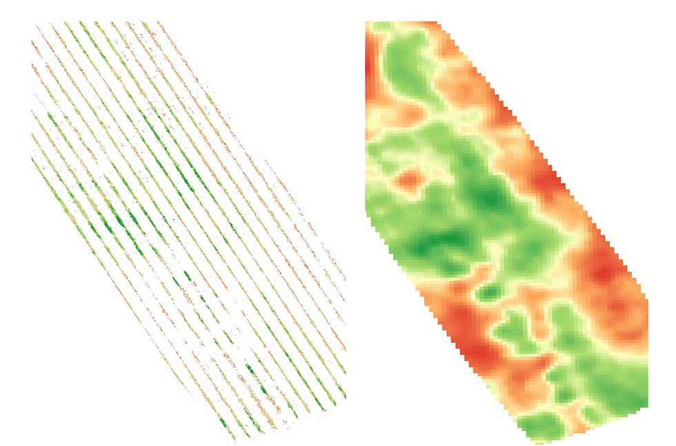
Surveys conducted to identify biotic and abiotic crop stresses. The drones used here are equipped with different types of cameras that can be multispectral (the most commonly used), hyperspectral, and thermal. Using these surveys, it is possible to identify in which portions of the field there is greater vegetative growth, increased temperatures, and easily identify the weed in a field. In this case, the data from these surveys must be processed and interpreted by experienced agronomists who have experience in photogrammetry and spectrometry. In addition, it is essential to perform specific processing such as data segmentation in order to perform analyses on crop rows only. Here below is one our elaboration done in Moie - Italy - Marche.

Distribution of agronomic inputs, In this case, drones replace the use of agricultural vehicles for the distribution of auxiliar insects, fertilizers and agropharmaceuticals. Basically, these drones are equipped with hoppers that allow the drone to be loaded with the input to be deployed, and then at specified times they are released into the environment. Until recently, European regulations prohibited the distribution of plant protection products in the environment, but as of today through certain authorizations, one can proceed with their distribution if one has suitable UAV patents.

Classification based on the drones type
Based on the drones type we have four main categories of drone type, which are Multi-Rotor and Fixed-Wind, Single rotor and hybrid VTOL.
Multi-rotor drones are the most popular drones used in agriculture. They allow vertical landing and takeoff, and they are used both to do photogrammetric surveys and to do agronomic input distribution. Do not allow you to cover hundreds of hectares but they are the ones you will see most in rural areas.

Fixed-Wind, These drones have the ability to be able to survey large areas in a single flight. They do not have a vertical takeoff or landing but are assisted by us during takeoff. They are very interesting but still today the prices of these drones are very prohibitive. They can be equipped with multispectral camera.

Single rotor, are drones that are like helicopter. They are not so famous yet in the agriculture domain but they could be used for input agronomic distribution cause they can carry a really large weight.

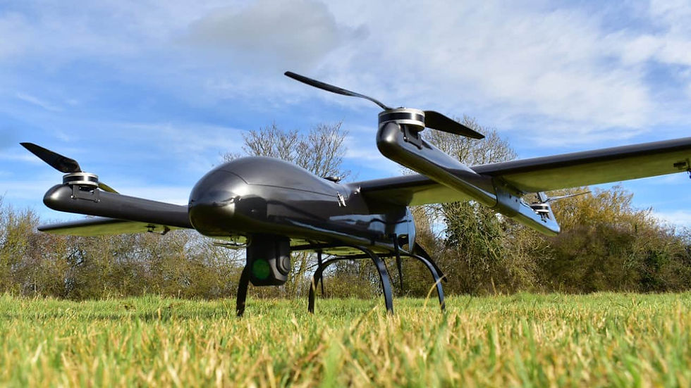
hybrid VTOL, These drones are not as famous as multi-rotor drones, but they can cover thousands of acres of relief because of their ability to take off vertically and then be able to do a flight like fixed-wing drones. It basically combines the major advantages of both types of drones. They are very expensive but have enormous potential.

Type of camera equipped in drone used in agriculture
As previously mentioned, drones by their very nature are means of transport, and therefore on their own they would not have any potential use in agriculture, but if they are equipped with special cameras, they can be very useful in agriculture. Below we make a list of special cameras used in agriculture and some practical examples of their use, which are:
Multispectral Camera
Thermal Camera
Hyperspectral Camera
Multispectral Camera
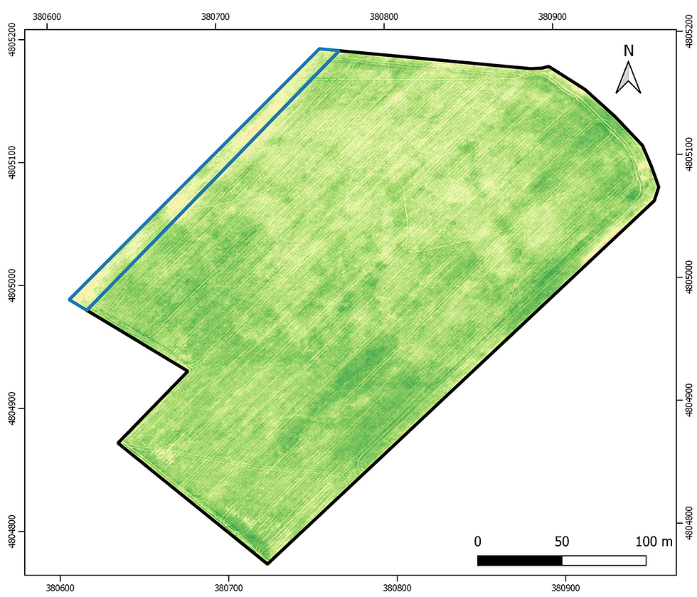
Multispectral cameras are the most used, famous and studied cameras in agriculture. They have been used for decades for scientific research because they have great application capacity. In fact, today they are also installed in satellites to carry out constant monitoring in the agricultural field. These cameras have the enormous capacity of being able to calculate vegetation indices (like NDVI) starting from multispectral bands and allow the crop growth monitor. An example is shown below, where we made many multispectral surveys over a wheat field.

Starting from these drone images it is then possible to create prescription maps that allow the agronomic inputs to be distributed in a differentiated manner. Here below the prescription map applied to the same field.
Thermal Camera
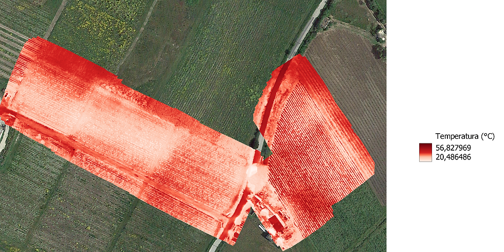
Thermal images are of absolute importance for the management of irrigation of agricultural companies, in fact they return a map which shows the temperature of the leaves. In fact, when a plant carries out photosynthesis, it has opened its stomata and exchanges gases with the outside, and this allows it to cool the temperature of the leaf. But when under water stress, as a conservative strategy, the plants close the stomata and deny gaseous exchange, raising the temperature of the leaf. This rise in leaf temperature can be detected by thermal cameras. In fact, as a rule, plants are under water stress when the temperature of the leaf is higher than that of the air.
Below we leave you an example of a thermal map that allows you to identify the cool areas and the hot areas, and obviously the areas with a high temperature are related to significant water stress.

Hyperspectral Camera
Hyperspectral imaging is the future of spectrometry in agriculture. They are very advanced optics that have already been used in other contexts such as:
Know the composition of the planets
Identification of anomalous molecules in foods
Material inspection
And today these cameras are slowly making their debut in agriculture too. hyperspectral cameras can be used for various applications that other cameras cannot do:
Identify nutritional stresses, for example identifying whether nitrogen or phosphorus or potassium is lacking
Identify the presence of pathologies
Do soil organic carbon mapping
However, they have important defects that are slowing down their applications in agriculture, and they are:
Very expensive, costs around 50-100k euros
The data generated is immense, and therefore their storage and processing is not so obvious or easy
A very high level of competence is needed to be able to carry out specific processing
Below we leave you an image that shows what a hyperspectral image, or a data cube, actually is.

Drone vs satellite: David vs Goliath
In order to fly over our fields, there are not only drones, but rather every day without our knowledge, satellites constantly pass over our fields, generating data of absolute importance for agronomic management.
if you want to learn more about satellite and their application in agriculture, visit this article
But which technology should i use? drone or satellite? Let's check what the advantages of one and the other are, so that we have a full overview.
With drones we can do surveys whenever we need them, weather permitting, with a ground resolution ( 1 cm2 ) that satellites ( 9 m2 ) still cannot provide us with today, but on the other hand to do a survey with a drone we need:
buy a drone
purchase a camera of those previously mentioned
have an appropriate license for the operation
get a drone insurance
vehicle registration
charge batteries, head to the site on which to survey
perform the survey
perform the entire processing phase
and at the end we have a high resolution images and all these steps is an expensive activity that needs special expertise.
Whereas with satellite, all you have to do is access, from the comfort of your home, download the satellite image and perform processing on it. With zero cost and risk, but at the same time, we have:
lower spatial resolution up to 100 m2 compared to drone survey
we have a satellite image every 5 days

So the choice depends on the budget but mostly on the crop and how it is grown, so to be clear let us give you a couple of examples:
a cereal crop, so open field, the use of satellite imagery it's ok.
of horticultural crops, on the other hand being row crops for the most part, perhaps where there is also a mulch, the use of drone imagery is recommended, because be have a suitable ground resolution to be able to distinguish crop, mulch and inter-row.
a vineyard with a row spacing of about 2 meters or more only drone or very high resolution satellite imagery from 3 meters down is recommended
Who will win drone or satellite for the future?
with no doubt it will win satellites for crop monitoring but for agronomic input applications the drone will be a viable alternative and one that will have much room in the future.
In fact, many of the drone manufacturers are gradually giving more attention in research and development to drones that can carry large weights to be able to do agronomic input applications very similar to agricultural tractors
So for the future there will be fewer and fewer drones for monitoring and more and more drones for agronomic input distribution.
Key Benefits of Drones for Farmers
Surely you are wondering what the benefits are for a farm to access such data? There are many, and below, we are going to list a number of tangible benefits of using drones in agriculture:
Crop growth monitoring
Water status monitoring
Define the soil sample points and digital soil mapping.
Generation of prescription maps for fertilization, irrigation, and plant protection products
Distribution of auxiliary insects (used in organic farming but also in integrated and conventional farming)
Distribution of fertilizer and plant protection products
Agricultural insurance
Agricultural Certification and supply chain control
Case Studies: Successful Drone Implementations
Here below we will show you how different farmers used our drone survey services for their applications.
Solomeo
At Solomeo, multispectral surveys were conducted on a 6-hectare vineyard in the 2023 vintage, and these data were used to:
identify the different zones of leaf development
Plan differentiated organic fertilizations
Determine mixtures of legumes and grasses to be included in the row spacing

Sarteano
In Sarteano a vineyard of more than 12 hectares, a multispectral survey was carried out in order to identify:
zones of differentiated development
plan for differentiated collections
Plan differentiated organic fertilizations
Determine mixtures of legumes and grasses to be included in the row spacing

Recanati
In Recanati, multispectral surveys were conducted on durum wheat during the 2020-2021 crop year, and these surveys were used to create prescription maps for seeding and fertilization

Moie
A multispectral survey was conducted in Moie over more than 10 hectares to
zones of differentiated development
plan for differentiated collections
Plan differentiated organic fertilizations
Determine mixtures of legumes and grasses to be included in the row spacing

University of Perugia
Very advanced experiments on the use of satellite imagery to identify biotic and abiotic vine stresses have been conducted at some of the wineries involved by the unverisity of perugia.

Explore with us the potential of use of drone in agriculture
Do you also want to perform a drone survey? We provide not only a survey, but also specific processing accompanied by agronomic consulting, implemented to bring the analysis conducted on the acquired images into the field.
If you would like more information please contact us below


Comments